Central Park North

Harlem Meer

I have written previously about the value of a view of nature – how our animal selves need to connect to plants or animals even within New York City’s urban jungle. While not NYC’s largest park (that would be Pelham Bay Park in the Bronx), Central Park is an amazingly large green space within the relatively small island of Manhattan. The increase in value a view of Central Park, or even proximity to it without a view, delivers to an apartment in New York City is well established. Most tourists only see, or even think about, the south end of the park, closest to Midtown, However, the northern third of the park is equally beautiful, and the price of an apartment on Central Park North (110th Street) is a fraction of that on Central Park South (59th Street). I enjoy taking unplanned walks around the city (dérives) and decided to walk along the edge of Central Park, starting on Central Park West and 86th Street, crossing the top of the park at Central Park North, and then heading south along Fifth Avenue, stopping at 86th Street.

At the corner of Central Park West and 86th Street, you stand flanked by Central Park to the east, facing a row of Central Park West’s grand prewar apartment buildings to the west. Many of the east-facing apartments in these buildings in the upper 80’s/low 90’s have wonderful views of the Jacqueline Onassis reservoir (living on Fifth Avenue, she was well known for using the jogging path around the reservoir). Continuing north, large outcroppings of ice age Manhattan schist can be seen, forming a natural cliff at the edge of the park. I was struck along this section by the Eldorado, the most northern of the several “twin towered” buildings along CPW (the San Remo, the Majestic, and the Century being farther south).

When you walk to the Northwest corner of CPW and 110th Street (which is called Central Park North for obvious reasons between Central Park West and Fifth Avenue), a statue of Frederick Douglass can be seen, gazing up the Avenue bearing his name. His is a fairly new statue, only being revealed in 2010. Turning east on Central Park North, it is clear that this section of park-facing apartments is a mixture of older tenement-styled buildings, and a few spectacular new development properties. It seem that this is only the beginning of the development of this stretch of real estate, with the potential for views south encompassing the entire length of Central Park as well as the Manhattan skyline. I have seen the spectacular view that apartments facing north on Central Park South have, but so far can only imagine how amazing those same views are from the north with the Empire State Building, Chrysler Building, and new icons like One57 and 432 Park rising up behind the park.

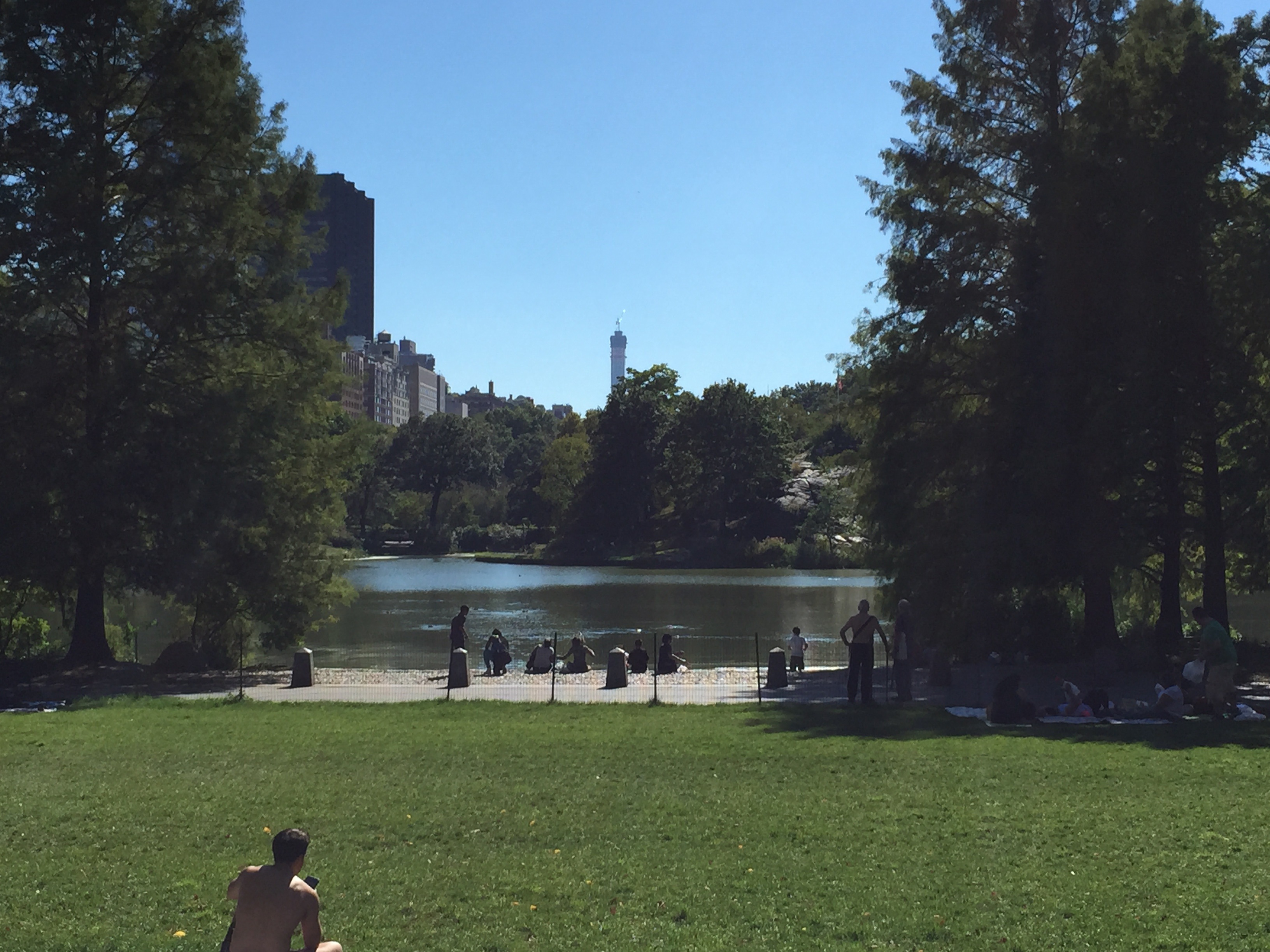
Within the north section of Central Park, beautiful and serene Harlem Meer (“meer” is simply a “lake” in Dutch, New York City’s first language) anchors the recreational possibilities for this area. Catch-and-release fishing are available (yes, people can actually fish in Central Park), and Lasker Rink provides ice skating in the winter but is transformed into a swimming pool in the summer. There is a Harlem Meer performance festival every summer, well worth visiting regardless of where you live in the city.

At the Northeast corner of Central Park North and Fifth Avenue, a statue of Duke Ellington (complete with piano) honors his importance in the Harlem Renaissance of the 1920’s, 30’s, and 40’s. A committee led by cabaret singer Bobby Short raised the money for this statue in the 1980’s. Turning onto Fifth and heading south,  One Museum Mile, a new residential development designed by Robert A.M. Stern Architects signals the change to what some call “Upper Carnegie Hill.” Passing the lush and elegant Conservancy Gardens, the Carnegie Mansion (home to the Cooper-Hewitt Museum), and the Guggenheim, Fifth Avenue slowly evolves into the street we imagine, stately apartment buildings side-by-side facing the park.

What I have learned from exploring Central Park and the streets facing it is that the Park is truly a kind of miracle – such an oasis of multi-layered nature surrounded by our great city. Living in close proximity to the park is a gift, and one with a price. However, the price is lessened on the north section of the park, and offers great value for those looking to live near this green jewel within the island of Manhattan.

Little Italy

Lombardi2

My last blog post about taking an unplanned walk through an urban environment (a dérive) in New York City took place in Chinatown. Just north of Chinatown, but in practicality blending with it for many blocks, is a section of lower Manhattan referred to as Little Italy (in fact, Chinatown and Little Italy have been grouped together and made one historic district within the National Register of Historic Places). The boundaries of Little Italy have always been fluid, but Mulberry Street is its epicenter. While at one point it might have encompassed the entire area between Houston and Worth to the north and south, and Lafayette to Bowery to the west and east, today it is really only the three blocks of Mulberry north of Canal Street that consistently retain an Italian flavor. In many senses, Little Italy is a bit of a theme park – very few people of Italian descent still live in the area (there are much larger Italian-American populations in the Bronx and Staten Island, for instance), unlike Chinatown, which still holds a large group of Chinese-speaking residents. Theme parks can be enjoyable, however, and I set off to walk around the area to experience it.

Crossing Canal on Mulberry Street, you are welcomed to Little Italy with banners and decorations in the colors of the Italian flag. These few blocks are the location of the Feast of San Gennaro, an eleven day street fair held around the feast day (September 19) of the patron saint of Naples. Featured in its original form in The Godfather (parts II and III), the San Gennaro celebration today attracts many visitors and locals to the area as more of a food and drink festival. Speaking of The Godfather, far from shying away from the neighborhood’s past association with organized crime, I noted that the stores in the area seem to celebrate it as a way to sell t-shirts.

Most people come to Little Italy to eat, and if you walk north of Mulberry Street, you will likely be spoken to by the employees of multiple restaurants as you progress. Few New Yorkers head to Little Italy for authentic Italian food, however – there are plenty of good Italian restaurants all over the five boroughs of the city (the Bronx around Arthur Avenue, for instance). On the day I was wandering the area, however, my thoughts turned to pizza. True New York pizza., while quite different from what you would find if you ordered pizza in Naples or Chicago, is one of those quintessential elements of living in the city, like bagels. An average New York “slice” bought on the fly is better than most pizza bought at a more upscale restaurant outside the city, in my opinion. More importantly, New York City brought pizza to America, and walking out of today’s Little Italy and into Nolita (north of Little Italy) leads me  north on Mulberry to Spring Street, stopping at the corner of Spring and Mott to gaze at the birthplace of New York pizza: Lombardi’s. Opened by Italian immigrant Gennaro Lombardi in 1905, it took the concept of the Neopolitan pizza pie, but adapted to fit the location (a coal-fired oven – still used – rather than wood burning; fior de latte cheese rather than mozzarella di bufala). Although his employees left to found Totonno’s, John’s and Patsy’s – all competitors in the heated race for most authentic NYC pizza – Lombardi’s was the first. When I am asked by visitors where to go for real NYC pizza, I always recommend Lombardi’s. However, unless you go at an odd time, prepare to wait for a table.

As I mentioned before, Little Italy seems more like a theme park and less of a real neighborhood these days. As New York City continues to evolve, however, I find that the ghosts of former neighborhoods leave some trace behind, a flavor or imprint despite the new buildings or souvenir shops. For me and for this place, that moment is in tasting authentic New York pizza, created by Italian immigrants and uniquely adapted to this city – part of the endless cycle of immigration and assimilation that has made the city the vibrant entity it is and will continue to be.

Chinatown

Columbuspark1

Taking an unplanned walk through an urban setting (a dérive) is one of my favorite activities, and New York City – where walking a few blocks can completely change your surroundings – is the ideal city for this. For this dérive, I got on the subway at Lexington and 86th Street, took the 6 train downtown, and emerged at Canal Street, where the first thing I saw was the typical golden arches of a well-known fast-food restaurant. Indicative of how far I had traveled despite the short subway ride, however, the writing on the sign was solely in Cantonese.

There are many neighborhoods within the five boroughs of New York City with large populations of ethnic Chinese, but this area in lower Manhattan is what most people think of when the term “Chinatown” is used in the city. There are no clearly defined borders, but roughly the neighborhood could be though of as being bordered by Broome Street to the north (there are a few blocks where Chinatown and Little Italy overlap), Chambers Street to the south (touching the Financial District), East Broadway to the east, and Broadway to the west (bordering TriBeCa). Formed during the mid-1800’s, when new laws were enacted on the West Coast limiting participation in some occupations, by 1900 there were 7,000 residents of Chinatown. Most residents were traditionally Cantonese speakers, but Mandarin is beginning to be used as well. Today’s population is estimated to be 90,000 to 100,000, in a relatively small number of blocks and without many high-rise buildings, leading to the packed and bustling nature of the neighborhood.

Starting on Canal Street and Lafayette, for this derive I began walking east along Canal. Chinatown is not a place to walk if you are in a hurry to get somewhere – the streets can be extremely crowded. Canal Street is lined with shops, many of them featuring inexpensive New York souvenirs for tourists. Fruit vendors with good quality and very inexpensive produce also appear along Canal (further limiting the sidewalk for movement of crowds).

Just after Canal Street merges with Walker Street, I took a turn south onto Mulberry Street. As soon as you get off Canal, the crowds thin and it is easier to appreciate the character of the neighborhood. Most signs are in Cantonese as well as English – and some omit English altogether. Restaurants abound in the area. Most New Yorkers have strong opinions of what the best restaurants are in Chinatown, but in my opinion it’s fun to simply decide to stop in at any restaurant that catches your eye. When on jury duty a few years ago, my fellow jurors and I walked to Chinatown during lunch recess, trying a different restaurant every day. Approaching Bayard Street, the Chen Dance Center (http://www.chendancecenter.org/) is on the east side of Mulberry, and holds a school for dance as well as performances of modern dance reflecting Asian aesthetics by its resident company.

Crossing Bayard Street, Columbus Park beckons to the west. Sitting on land once considered to be the most dangerous area in New York City (Five Points, immortalized in the book and film, “Gangs of New York”) and bordered by Bayard, Mulberry, Worth, and Baxter Streets, I found Columbus Park to be a delight. As soon as I entered the park, I could hear musicians playing the erhu, a Chinese stringed instrument. The park was filled with people playing board games as well as more active sports, reading Chinese newspapers, and practicing tai chi. The park somehow seemed simultaneously bustling yet peaceful, and I found myself completed immersed in the atmosphere of the park.

I was recently visiting New Orleans, and commented to my daughter that one of the things I loved about being there was that I knew instantly that I was in a different place. While walking around Chinatown, however, I realized that I don’t need to go out of the country, or out of the Northeast, or even out of New York City to have that same feeling of being immersed in a completely different environment. That’s one of the tremendous advantages to living here in New York City, where a walk of a few blocks can take you just as deeply into a new environment as landing after a lengthy plane ride.

Battery Park City

Battery Park city

A few months ago, I wrote about an unplanned walk through an urban environment (a dérive) I had taken through one of the hottest neighborhoods in Manhattan – Tribeca. Today’s derive starts where Tribeca, the Financial District, and Battery Park City intersect, at Chambers and West Streets. I often like to write about the history of the area I will be walking through, but Battery Park City, the site of today’s journey, is a newborn compared to most of New York City. Battery Park City sits on land created in large part from soil and rock excavated during the building of the original World Trade Center in the early 1970’s. One of the earliest uses of the newly created land was for seating areas to watch the “Operation Sail” flotilla during the celebration of the American Bicentennial in 1976. Construction of residential buildings began in the 1980’s and has continued since then, with 11 buildings constructed in the 2000’s and three new buildings so far in this decade.

Crossing busy West Street over the pedestrian Tribeca Bridge, you realize what spectacular views this neighborhood has of the new One World Trade Center building (recently officially declared the tallest building in the Western Hemisphere, besting the Willis Tower in Chicago after a contentious ruling about  antennae versus spires). Stuyvesant High School  lies just over the west side of the bridge. This elite public high school boasts four Nobel laureates among its alumni, and only about 3% of all applicants who take the rigorous standardized admissions test are lucky enough to attend, with no tuition. The high school’s building was erected in the early 1990’s, and marks the northernmost edge of Battery Park City.

Between Stuyvesant and the Hudson River sits the entrance to Nelson Rockefeller Park, a gorgeous spacious park with views of Tribeca and sailboats to the north, and Ellis Island and the Statue of Liberty to the south. This park, on the sunny summer weekend day I was there, was filled with bikers, sunbathers, families with strollers, pets walking their humans, and people playing games from basketball to chess – the area was vibrant and welcoming. All along the east side of the park, tall apartment buildings face the Hudson, with occasional views of One World Trade framed in intersections a few more blocks to the east.

Just beyond the residential buildings to the east lies the Goldman Sachs complex, and continuing south, Brookfield Place, which holds several financial companies as well as the Winter Garden, which holds free concerts and other events throughout the year. Near the Winter Garden is a yacht harbor. The businesses in the area contribute to the restaurants and shops that support the area’s residents as well. Continuing south, the bulk of the residential buildings exist in three developments, Gateway Plaza, Rector Place, and Battery Place.

One thing that is important to know is that all the buildings in Battery Park City lease their land from the city rather than knowing it outright, but your broker and attorney can  explain how that affects a particular building you might be interested in. In addition, there is no direct subway service to Battery Park City, but there are bus lines, and the subway and PATH lines servicing the financial district are only a few blocks to the east. The surprising thing about this neighborhood is how quiet and peaceful it seems, just a few blocks from the center of the financial district. Although the real estate value has rebounded in the last few years, there is still a variety of apartments available at many price points. If you are interested in potentially moving to this area, I would recommend visiting it a few times, on a busy weekend afternoon and perhaps also on a weekday evening. I wrote a few months ago about the value of an iconic city view, and if this appeals to you, it is hard to imagine a view more iconic than that of the Statue of Liberty, just one of the advantages to this new and vibrant neighborhood in Manhattan.

The Upper West Side: from Central Park to Riverside Park

UpperWest

In a past dérive (an unplanned walk through an urban environment), I started at the corner of Central Park West and 81st Street, and walked south on CPW to Columbus Circle. For this dérive, the starting location is the same, but this walk goes from one great park to another: from incomparable Central Park west to the delightful Riverside Park, on the Hudson River. This walk illustrates why the Upper West Side continues to be a top location for residential real estate in Manhattan – it’s a primarily residential neighborhood, with a variety of different types of homes, and with all the neighborhood amenities one needs to enjoy life.

Starting at Central Park West and W. 81st Street, the Museum of Natural History dominates to the south. Founded in 1869 by a group including Theodore Roosevelt, Senior (father of President Teddy) to increase knowledge of the natural world in a time when zoos were relatively rare and limited in scope, and travel to see many of the wildlife shown was impossible for nearly everyone, it is a classic – but it can be a bit jarring to modern eyes to see stuffed and preserved animals, many of which are now endangered. Teddy Roosevelt became an iconic part of the museum, donating two elephants from one of his expeditions and eventually being honored by his image in the towering statue that welcomes visitors to the main building. Walking along W. 81st, however, eventually the Rose Center for Earth and Space, housing the Hayden Planetarium as well as many interactive educational displays, can be seen through the thick August foliage. It’s quite a change from the winter, when the glowing blue globe within a transparent cube can be seen from many directions through the leafless tree branches.

Behind the museum, on this Sunday afternoon, there is a greenmarket set up, with locally grown produce, honey, cheese, and bread. These greenmarkets are a wonderful addition to New York City life, and you can find out their locations and times at http://www.grownyc.org/greenmarket.

Turning west on W. 82nd, the characteristic nature of this neighborhood becomes apparent: larger stately apartment buildings on the Avenues and on the corners, and charming brownstones filling in the cross streets. The material covering brownstones is a type of sandstone from the Jurassic or Triassic eras, so having an abundance of brownstones so near the dinosaur skeletons at the American Museum of Natural History seems only fitting.

Passing Broadway, and then West End Avenue, I smile as I remember a recent conversation with an Australian looking for an apartment near Riverside Park. He wondered where all the theatres were, and eventually I had to explain that Broadway was only “Broadway” as he thought of it in the 40’s and 50’s, and that “West End” bore no resemblance to the same area in London! In fact, as you get closer to Riverside Park, the neighborhood becomes more peaceful and residential, eventually leading to the pastoral beauty of Riverside Park.

The Upper West Side holds a variety of choices for someone looking for a home – running the gamut from the stately views of Central Park or Riverside Park in the majestic buildings on Central Park West and Riverside Drive, to the quiet and sometimes quirky floor-through apartments in brownstones on quiet cross streets. I recently helped a customer find a pet-friendly home near Riverside Park (with its off-leash hours and dog runs), and was delighted when she saw the 500 square feet of outdoor space in a certain brownstone garden apartment and knew that she and her dog had found their perfect home. Everyone looking for a home in New York City deserves the same result, and with the abundance of different neighborhoods and types of residences, with patience and the help of a good broker, it should be possible.

In the Heights

WashingtonHeights

This week’s dérive (an unplanned walk through an urban environment) takes place in a Manhattan neighborhood that holds Manhattan’s oldest surviving mansion, has a safer crime rate than Greenwich Village, is only 20 minutes from Times Square via express subway, and was the subject of a recent Tony Award winning musical – Washington Heights. Surprised? It’s time to take a closer look at this northern Manhattan neighborhood while there is still value to be had in this rapidly-evolving area.

Washington Heights lies just above Harlem, just below Inwood (the very top of Manhattan), and between the Hudson and Harlem Rivers. It is in named for Fort Washington, the highest spot in Manhattan and the site of a major battle with the British during the American Revolution (we lost that battle, but of course won the war). Currently the area has a large Dominican population (who descriptively call the neighborhood, “El Alto” for its hills and elevation), and the conflict between the existing residents and the process of gentrification was one of the themes of Lin-Manuel Miranda’s award winning musical, “In the Heights.” New developments are beginning to be built in the area – I recently sold such an apartment to investors and will be renting it out for them. After taking photographs of the apartment, it was time to take an unplanned walk in the neighborhood and discover its personality.

Starting at W. 168th Street and St. Nicholas Avenue, I will note that Washington Heights is actually easier to get to than some neighborhoods closer to midtown but without as many public transportation options. The A train (express) can get you to midtown in 20 minutes, and the C (local) and the 1 makes several stops along the Broadway line in the Heights. Dominating the area at the 168th Street stop is Columbia Medical Center. Surprisingly, the land it sits on was once the home of Hilltop Park, the home of the New York Highlanders baseball team from 1903-1912. They eventually moved their ballpark to the Bronx and changed their name – to the New York Yankees.

Walking east along W. 167 Street to Edgecombe Avenue, you dead end at a surprisingly pastoral park along a high bluff. Huge sections of the Manhattan schist left over from when the ice age receded form the edge, and tower to your left as you walk south along Edgecombe. At 162 Street, I was intrigued by a sign to the right for the Morris-Jumel Mansion, and walked along 162nd before turning onto Jumel Terrace to see a large white mansion with pillars. Built in 1765, it was used by George Washington for his headquarters for a few months in 1776, and at various times hosted guests as illustrious as Thomas Jefferson, John Adams, and Alexander Hamilton. A National Historic Landmark since 1961, it is now a museum decorated entirely in the Georgian style, with a bed that supposedly belonged to Napoleon.

Continuing along W. 160th Street after turning from Jumel Terrace, there are beautiful rows of townhouses as well as a few large prewar apartment buildings. Turning south on Broadway, a bustling, but not overly crowded, thoroughfare awaits with plenty of shopping and restaurants. At W. 155th Street, the southern edge of Washington Heights, I was surprised to see a large (over two full blocks) cemetery, part of Trinity Church Wall Street but created in 1842 because they had run out of space in their downtown location. Still in use (recent additions were Mayor Ed Koch and Jerry Orbach), it has a large monument for John James Audubon, the famed naturalist best known for his detailed illustrations of birds. His name graces a nearby micro-neighborhood within Washington Heights – Audubon Terrace, a series of eight Beaux-Arts buildings in what was once his land. The nearby apartment buildings on Riverside where it makes a sharp eastward turn between 155th and 158th Streets represent a hidden gem within Manhattan real estate, a C train stop to get you to the rest of the city, but seemingly quiet and removed from it.

Taking the C back downtown, I reflect on the surprising variety of experiences available in this less-known (and perhaps misunderstood) area of Manhattan. Regardless of how long a person has been living in New York City, the richness and uniqueness of its many neighborhoods always allows for fresh discoveries – and in this case, the potential for great value in real estate.

Flatiron District

Flatiron

Some neighborhoods in New York City are named after their geographic location (Upper East Side, for instance), others for historic reasons (Greenwich Village was once Groenwijck, or green district, in the time of New Amsterdam and was in fact a village), but today’s dérive (an unplanned walk through an urban environment) is in a district named instead for an iconic building – the Flatiron. Because of the diagonal swath that Broadway cuts across the grid system in Manhattan, occasionally interesting intersections occur. Times Square is the result of the intersection of Broadway and Seventh Avenue, and the iconic Flatiron Building occupies the triangle formed when Broadway and Fifth Avenues cross between 22nd and 23rd Streets.

Surprisingly, the location of the Flatiron Building was an early sort of prototype for Times Square. The Cumberland, a seven-story apartment building on the site in the 19th Century, leased out the top four floors to advertisers, including the New York Times, who created a sign made up of electric lights. The owners of the lot eventually put up a canvas and projected an array of advertising photographs on the side of the building. In 1901, construction on a new skyscraper (22 stories!) was started, and the building was finished a year later. This part of Manhattan is in the section where the bedrock, or schist, is much deeper from the surface than in lower Manhattan or midtown, so when the Flatiron Building (technically named the Fuller Building, but the inevitable nickname stuck) was being built locals took bets on how far the debris would fall when the building collapsed. However, the steel skeleton used for the building, and the elegant Chicago-school Greek column construction, has ensured that it has sturdily anchored the area over well over a century.

So what is the Flatiron District? As a informal name to a neighborhood, there are no set boundaries, and in fact the term only gained popularity in the 1980’s. Originally an industrial area with an abundance of photography studios due to the low rents, and sometimes called the “Toy District” because of several toy manufacturers, the neighborhood has evolved into one of New York’s top residential areas downtown. As the area gentrified and became more residential, real estate agents needed a term to describe the neighborhood, roughly from 20th to 25th Street and from Sixth or Seventh Avenue to Lexington, and naming it after the landmarked Flatiron Building made the location clear.

Starting a walk through the neighborhood by standing in front of its namesake (where else?), it’s hard to decide which way to go, with Eataly (Mario Batali’s emporium to Italian food and drink, with various restaurants – or purchase products for home use) beckoning at Fifth and 23rd, and the original Shake Shack nestled in Madison Square Park at about Madison and 24th Street. Walking through the park, one is reminded that this is the source of the name for Madison Square Garden, originally just north of the park but now in its fourth location above Penn Station. The MetLife Tower at Madison and Fifth was once the tallest building in the world (700 feet tall) until being unseated by the Woolworth Building in 1913. The enormous clock on the top is visible from far away (I recently saw one of the new penthouses in the Puck Building in SoHo with a direct view of this clock from the bedroom) and a symbol of the neighborhood. Of course, many of the new apartments at One Madison would have a terrific view of the clock.

The Flatiron district combines residential use with shops, restaurants, and businesses. Many of the tech companies in the district and surrounding areas have led to a description of this as New York’s “Silicon Alley,” and there are also many advertising and financial firms in the area.

Williamsburg

Williamsburg

My previous blog posts about taking a dérive (an unplanned walk through an urban environment) have all happened to be located in Manhattan. However, it’s time to get off the island and explore one of the hottest neighborhoods in the city. Bordered by Greenpoint, Bed-Stuy, Bushwick, and the East River, Williamsburg has rapidly evolved in the past decade, with the housing price increases to prove it.

The area of Williamsburgh (yes, there was once an extra h) was within the town of Bushwick during the days of New Amsterdam. It became the city of Williamsburg in 1852, and was annexed into Brooklyn just three years later. Cornelius Vanderbilt built a mansion in the area next to the river in the late 19th century, and the economy boomed with factories (in a perfect reflection of the area’s change, the old Domino’s Sugar Factory was recently the site of a large scale public art project by Kara Walker). The building of the Williamsburg Bridge in 1903 led to swarms of immigrants from Manhattan’s Lower East Side, and Williamsburg became the most densely populated area of New York City (itself the most densely populated area in the United States). After World War II, the neighborhood became run down, and although many artists settled there, it took a major rezoning in 2005 to spur redevelopment of the abandoned warehouses into residential buildings.

The first subway stop in Brooklyn on the L Canarsie train is Bedford Avenue, and it’s a perfect place to start exploring this charming area. Walking north along Bedford, you immediately get the feeling of the neighborhood. Generally, low rise buildings and rows of townhouses predominate until you reach larger warehouses and new development high rises near the river. Shops tend to be unique rather than branches of mega-chains. Bedford eventually dead-ends at McCarren Park, which borders Williamsburg and Greenpoint and hosts the SummerScreen free movie festival (you are too late to see Zoolander this summer but Cry Baby, Heathers, and The Big Lebowski are still ahead).

Turning west toward the river on 11th Street, within a few blocks you can smell the hops at Brooklyn Brewery before you see it. Their small batch tour (Monday-Thursday at 5) is highly recommended, but you have to reserve online a month in advance or will likely not get in (each tour is limited to 30 people). Your $10 admission pays for a guided tour of the working brewery and curated tastings of four of their beers. On Fridays there are no tours but people line up to purchase tokens ($5 each) and taste very fresh cask beer. Saturdays and Sundays there are free tours, and beer available for purchase ($5 per token). The hieroglyphs on the side of the brewery say, “Beer has dispelled the illness which was in me,” so a stop at Brooklyn Brewery could perhaps be seen as a necessity for your health (that’s my story, anyway).

Turning south on Kent Avenue, you can see the Manhattan skyline just over the East River. The most spectacular view of Manhattan I have ever seen was from the rooftop garden of an apartment building on Berry Street in Williamsburg, but I don’t personally believe that a view of Manhattan is what Williamsburg is about. Passing the Music Hall of Williamsburg on 6th Street when heading back to the subway, I remember fantastic concerts I have attended and notice five or six places I would like to return to and stop for food or drinks. Williamsburg is easy to get to from Manhattan, and vice versa, but it doesn’t need Manhattan to charm a visitor, or perhaps to turn a visitor into a resident.

Alphabet City

AlphabetCity

In a recent blog post about taking a dérive (an unplanned walk through an urban environment) on Sutton Place, I mentioned that, because of the geography of Manhattan, there are occasionally Avenues east of First. I was recently in one of these areas; a subdivision of the East Village informally called “Alphabet City.” Avenues A, B, C, and D stretch between Houston Street to the south and 14th Street to the north, between First Avenue and the East River. Avenue A later reemerges as Beekman Place, Sutton Place, York Avenue, and Pleasant Avenue at various points to the north, while Avenue B reappears briefly as East End Avenue between 79th Street and 92nd Street – Avenues C and D are the easternmost parts of the island of Manhattan and only exist in Alphabet City.

Interestingly enough, the area was originally a saltwater marsh, but was drained and developed in the early 1800’s. In the mid-19th century, it became a hub for German immigrants, but after they decamped for Yorkville in the 1880’s, the neighborhood grew into one of the most densely populated areas of Manhattan. By the 1980’s Alphabet City was home to many struggling artists (immortalized in Jonathan Larson’s Rent), but since then, has been increasingly gentrified (with the increased housing prices to prove it).

For this dérive, I began by walking from Second Avenue and 3rd Street in the East Village, until hitting Avenue A. Just on the east side of Avenue A is the entrance to Upright Citizen’s Brigade East. One of three theaters run by UCB (the other two are in Chelsea and in Los Angeles); UCBEast showcases improv and sketch comedy seven days a week – at very affordable prices. The streets in Alphabet City are surprisingly quiet and tree-lined, although many garage doors and brick walls have become the canvas for expressionistic and colorful murals. This street art is such a part of the character of this neighborhood that there is even a children’s book called Alphabet City –Out on the Streets (by Michael de Feo) that illustrates the alphabet with the backdrop of street scenes in the neighborhood.

Continuing past Avenue B, turn north on Avenue C to experience the most bustling ambiance of the avenues in Alphabet City, every block showcasing trendy boutiques, restaurants, or bars. At Avenue C and 10th Street, stop inside the Museum of Reclaimed Urban Space (MoRUS) for a reminder of the community activism that has long been a part of this neighborhood’s character. MoRUS also holds exhibitions relating to the historical implications of housing cycles within different urban neighborhoods. Closed Monday and Wednesday, but open other days from 11-7, there is a $5 suggested donation for admission, well worth it to support a volunteer organization that promotes ecologically-sound urban environments. MoRUS also supports the network of community gardens that flourish throughout the Lower East Side. These community gardens sum up the feeling of Alphabet City today – a community with an abundance of opportunities for entertainment but also with pockets of quiet. Street art, nightlife, and gardens – all part of the complicated mix that makes Alphabet City another unique place to live in New York City. Viva la vie bohème!

Washington Square Park

Washington Square Park>
On a beautiful early summer weekend afternoon, I decided to take a dérive (an unplanned walk through an urban environment) in Greenwich Village. Getting off the 4 at Union Square meant being immediately immersed in a hub of activity – on this day, an extensive pet adoption event, but on other days, Greenmarkets, or a rally for political or social justice causes. Passing by the usual assortment of street performers (of note on this day was a group of older men performing 1950’s doo wop songs), I headed down University Place. Originally part of Wooster Street, this short stretch (from Washington Square to 14th Street) was renamed University Place a year after New York University was founded in 1838. Although the street is packed with places to eat and drink, I found myself magnetically drawn to Washington Square Park, beckoning to me a few blocks to the south.

Although all the surrounding blocks are named after the Square itself (Washington Square North, South, East and West), it is more helpful to think of the park as being bordered by Waverly Place and 4th Street to the north and south, and University Place and MacDougal Street to the east and west. Once a cemetery, and in fact the place that yellow fever victims were buried in the early 1800’s to contain the spread of the disease, in 1826 the square was leveled and turned into a militia parade ground. By the 1830’s, the city’s populace had begun to expand from the southernmost tip of Manhattan, and the Georgian revival homes along Washington Square North date from these times.

In 1889, a temporary arch was constructed in the park to commemorate the centennial of George Washington’s inauguration, followed in 1892 by the permanent Stanford White-designed arch that dominates the north end of the park today. Clearly inspired by the Arc d’Triomphe in Paris, it stands 77 feet tall. The two statues of George Washington visible on the north side were added later, in 1918. On the day I was there, a man played a grand piano (in hopes of tips, of course) just under the arch – I wish now I had asked him how he gets the piano to that spot and away again (and are the tips sufficient to be worth it?).

Washington Square Park is not truly a park that glorifies nature (most of it is paved over), but is more an urban park that encourages people to gather. On most days, but particularly on weekend days in warmer months, it is impossible to be in the park without experiencing several street performers. On this day, a woman was creating enormous bubble displays to the delight of several children, and in the drained fountain in the center of the park, a group of acrobats performed an elaborate show along with crowd participation. It is certainly possible to relax here and imagine Mark Twain and Robert Louis Stevenson discussing the joys of fame (as they did, according to Twain), but I find that Washington Square Park is more energizing that relaxing. Greenwich Village deserves several different dérives, since it varies dramatically from the surreal small town quiet of Washington Mews just one block north of the square, to bustling Bleecker Street, and runs the gamut between. Washington Square Park is certainly Greenwich Village’s hub, however, and always an entertaining way for residents and visitors alike to spend time and feel a part of this vibrant neighborhood.